Changing and continuous patterns
of regional development disparities in Hungary, 1910–2022
Róbert Győri and György Mikle
Background and methods
Regional disparities have been studied by geographers using quantitative methods for over six decades. Quantifying spatial social phenomena through indices like GDP and HDI became popular, and significant efforts have been made to introduce more sophisticated measurement tools. Our previous research mapped Hungary’s disparities at various historical points. This study expands on those by including data from the 2022 census to analyse continuities and changes to regional development over a century.
The research builds upon data from five key years (1910, 1970, 2001, 2011, 2022), harmonizing them at district level (174 LAU 1 districts) by aggregating settlement-level statistics. Variables selected for each year focus on standard of living, education and residential infrastructure, using metrics such as educational attainment (literacy rates for early 20th century), employment, income, migration and housing quality, while paying attention to changing data availability and definitions over time. 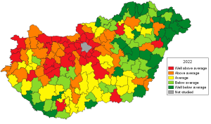 Based on these variables, cross-sectional standardised development indices were created for the years studied in order to map the changing spatial disparities within the country (see illustration for district development disparities in 2022), and to shed light on the role of directional spatial effects (west-east, north-south, centre-periphery relations).
Results
Hungary’s regional development disparities over the last century show strong stability shaped by long-term accumulated advantages or disadvantages rooted in historical spatial patterns. The persistent west-east divide, centre-periphery effects (especially the proximity to Budapest and Vienna), and spatially clustered development indicate that regional policies have encountered deep-rooted structural barriers. Spatial autocorrelation has grown stronger since the 1970s, indicating increasing zonal separation of developed and underdeveloped districts over time.
In 1910, Western Transdanubia and Budapest’s metropolitan area were the most developed, while northern and eastern regions, particularly Szabolcs-Szatmár-Bereg, were least developed. Socialist-era (1970) patterns revealed improvements in Northern Hungary and central Transdanubia, but also revealed peripheralization in large parts of the Great Plain and along post-WWII borders. At 2001 and beyond, the west-east division remained prominent with prosperous districts along Budapest-Vienna and Budapest-Balaton axes, while northern Hungary and parts of the Great Plain suffered industrial decline and persistent underdevelopment (mainly for being unable to adopt to the structural changes brought about by the transition of the 1990s). The top improvement in district ranking over the century is shown by resort towns (especially around Lake Balaton), outer Budapest metropolitan region, Southwestern Transdanubia, and one or two successful socialist industrial towns. The districts surrounding Budapest, county seats and their hinterlands, and some Transdanubian districts have been the most prosperous territories throughout the whole period analysed. On the other hand, the least developed regions have been the north-east zone of Hungary and the middle part of the Tisza region.
 Changing and continuous patterns of regional development disparities in Hungary, 1910–2022,
Róbert Győri and György Mikle,
Regional Statistics, Vol. 16. No. 1. 2026: 132–155; DOI: 10.15196/RS160106
